This article originally appeared in Volume I, Issue II of StoryBoard Memphis Quarterly in March 2022.
Few roads in the United States could be described as “iconic.” Reminisce long enough with native Memphians and you will soon believe that Summer Avenue is one of them. Not only is Summer Avenue an important part of Tennessee’s first state road, it was also the location of the world’s first Holiday Inn. And Summer is one of the few places where a search through its many quirky stores might actually yield Geronimo’s rifle and Marylin Monroe’s shampoo (if you never listened to Sheryl Crow just ignore that last sentence).
Recent attention by the City of Memphis, the Tennessee Department of Transportation (TDOT), and local citizens promises to make Summer Avenue even better. Through a grant from TDOT, the City of Memphis’s Division of Planning and Development has hired a consultant, Stantec, to draft a plan for guiding future investments. That plan is called the Summer Avenue Complete Streets Study.
Historically, pockets of pedestrian-oriented, mixed-use neighborhood centers, like the areas around Summer & National and Summer & Parkway, developed alongside establishments celebrating the automobile’s golden age. However, for the past half-century, many of the characteristics that make Summer Avenue such a great street have been eroding away, as the entire corridor has devolved from a people-centered street to a car-dominated road. The Complete Streets Study is intended to identify opportunities to improve safety and make Summer Avenue more inviting for all users, particularly pedestrians, cyclists, and transit users. Cities around the country are discovering that making urban environments more walkable results in some of the highest rates of return on public investment. It stands to reason that when cities create places that are safe and attractive, people spend more time there, and likewise, more money. Those places also tend to become social and cultural centers, thus strengthening community identity and becoming places citizens care deeply about.
The Corner
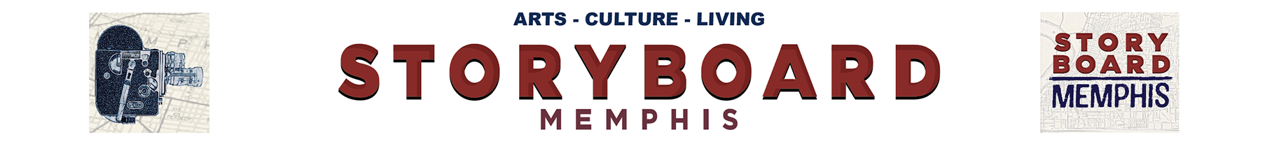
From the 1920s through the 1970s, the area along Summer roughly from National Street to Highland Street was such a vital and integral part of nearby neighborhoods that local residents simply called it “The Corner.” During the public participation stage of the Complete Streets Study, along with the recently completed Highland Heights Small Area Plan, several participants remembered walking to Summer Avenue to watch a movie, buy groceries, visit the bank, or simply meet friends and neighbors. The large clock sitting atop the Fortner Furniture building (later Bo-Jo’s Antique Mall) at the corner of Summer & National was described as a local architectural landmark. Handsome buildings constructed right up to the sidewalk greeted shoppers from all four corners of the intersection. The architectural significance of the buildings and their position relative to the street defined the public space and suggested to visitors that they had arrived in a place that mattered, that people cared about.
Over the years, Summer Avenue, including The Corner, has declined. The Fortner Furniture building was demolished in 2012, and in 2019, a mixed-use brick building on the opposite corner was also razed. Devoid of these once-proud structures, the area lost much of its distinctive identity, and became more like the generic, placeless, five-to-seven-lane roads found all over Memphis.
In the case of The Corner, real estate developers found it too easy to equate vacancy and deferred maintenance to blight, and sacrificed a future full of pounds for a short-term penny. In reality, however, it is more likely that policy, not blight, led to the obsolescence of the buildings at The Corner, and to the decline of urban centers in general. For decades, investments in public infrastructure were prioritized in undeveloped areas at the city’s periphery. And in established urban neighborhoods, instead of doubling down on their competitive advantage of diversity and walkability, policy made them play the same game that was being played in the suburbs. Once vibrant streets were transformed into sewers for car traffic. On Summer Avenue, on-street parking was removed, lanes widened, and land uses were rezoned for Highway Commercial.
Complete Street Plan for Summer Avenue
The conventional approach to street design is to move as many cars at as high a speed as possible. In designing streets for cars, they become virtually devoid of human life. Large parking lots, boring buildings, surrounded by loud, high-speed traffic are generally not places where people want to be. The idea behind a “Complete Street,” on the other hand, is to create a street that is safe, comfortable, and accessible to everyone. Repairing highways with Complete Street concepts is like the biological equivalent of allowing nature to return to a burned out forest. More often than not, providing spaces for a wide variety of transportation springs forth remarkable architecture, memorable places, and sustainable economic development.
A successful Complete Streets plan, however, needs to ensure that it is actually catering to all transportation users. This will look different depending on historical trends and existing conditions. For example, east of Highland, Summer Avenue is much faster and much wider. This section may be a good candidate for protected bike lanes and dedicated lanes for transit. However, west of Highland is much narrower and has historically been more pedestrian-oriented. On-street parking, fewer car lanes, safer pedestrian crossings, and wider sidewalks with trees and benches would be much more appropriate and would support the burgeoning private redevelopment that is already occurring.
Too often, motor vehicles are still given priority over people, even in so-called Complete Streets plans. Token design and policy decisions give some provision to non-drivers, but not so much that they encroach on the almighty car. As with Summer Avenue, many of the primary streets in our city are actually state highways, so ultimate decision-making falls to TDOT. Typically, TDOT practices have been favorable to motor vehicles, making authentic multi-modal transportation systems difficult to implement. This might play out on Summer Avenue as well, where boilerplate algorithms can strip down Complete Streets plans in places whenever the number of cars per day exceeds a certain minimum.
Fortunately for Summer Avenue, a high-capacity highway runs parallel for the entire project area and is never more than a quarter-mile away. This provides the perfect opportunity for through traffic to use Sam Cooper, so that Summer Avenue can be devoted to people who actually want to be there.
My grandfather used to say, “you are what you have been becoming,” and the still-iconic Summer Avenue has been becoming Anywhere, USA, for a long time. Fortunately, recent efforts like Memphis 3.0 and the Summer Avenue Complete Streets Study are attempting to reverse that. The lessons learned on Summer Avenue can be applied to similar traffic sewers all over Memphis. Roads like Poplar, Union, Jackson, Lamar, and others, can just as easily foster life-giving, prosperous, and beloved places – like the way many Memphians remember.
Feature image of Summer Avenue in 1958 courtesy of the Memphis Public Libraries.
On July 14, 2022, join community development problem solvers for “Planning to Practice: Memphis 3.0 Today” to discuss the latest efforts in smart city planning. Tickets available here.
Dane Forlines is the Director of Special Projects for the Heights CDC and lives in Highland Heights. Dane has written city-focused columns for StoryBoard Memphis since 2019.