A History of Memphis’ Most Maligned Street
“The past is never dead. It’s not even past.”
William Faulkner’s famous line, from his 1951 novel Requiem for a Nun, is often quoted, misquoted, or even misinterpreted. (It dealt with a fear of confronting a difficult past.) Faulkner’s line is often mixed up or used in conjunction with George Santayana’s equally famous “Those who cannot remember the past are condemned to repeat it,” which itself is often mistaken as a quote from Benjamin Franklin.
The misuse and misinterpretation of both famous lines come to mind when researching and writing about Memphis’ founding and founding fathers. Many Memphians can tell you that Jackson, Overton and Winchester are the names associated with the founding and planning of the new city of Memphis in 1819. What is often missed is that these men never actually lived in the city they founded, and as we are reminded in the following installment, barely step foot on the Fourth Chickasaw Bluff.
The Jackson-Overton-Winchester narrative has lived on almost as a fanciful myth. And in relaying the history of our Union Avenue, we cannot tell the avenue’s story without touching on Memphis’ early history and land ownership. Neither can we ignore the various myths associated with the city’s founding; there are many, and we address some of them here, along with a famous Union Avenue myth.
No, the past isn’t dead. It ain’t even paved yet.
When Memphis was founded on former Chickasaw Nation territory overlooking the Mississippi River in 1819, there was literally nothing in place except a trading post, wandering tribes, and the high ridges of the fourth bluff overlooking a mighty river at the western edge of the settlement. It took may years to mold this wilderness into a city of laws, ordinances, and civic responsibilities. ~Charlie Lambert
If you missed the Introduction to the Union Avenue Anthology, read Whatever Happened to Union Avenue? here first.
Part I, The Plan of Memphis: 1783-1827
The land on the bluff was known as the John Rice Tract, having been purchased from the State of North Carolina back in 1783 by Nashville land speculator John Rice. (The land already belonged to the Chickasaw Nation; after the Chickasaw Cession (1), negotiators Andrew Jackson and General Isaac Shelby would negotiate and settle five treaties with the Chickasaws beginning in 1786, settling lands across Tennessee and parts of Alabama and Mississippi for United States’ interests. With the last treaty in 1818 the Chickasaws turned over rights to the fourth bluff.) ~from James Roper’s “The Founding of Memphis,” West Tennessee Historical Papers
Early Doubts
Early on, there were doubts as to the value of the land. To the Chickasaws, the West Tennessee land on the Mississippi River was too prone to flooding to inhabit; they valued the area as hunting grounds. Andrew Jackson, officially one of the three city founders, had little to no interest in the land he owned by default through a standing agreement with John Overton (2). And it was said, that until its legislative incorporation in 1826, that Mississippi steamboats ignored it as a destination.
When (Marcus) Winchester arrived at the fourth bluff in 1818. . . there was little to suggest that the area could become a trading metropolis. During the 1820s, Bernard, Duke of Saxe-Weimar Eisenach, traveled down the Mississippi River and was unimpressed by what he saw. “Upon the fourth Chickesa [sic] Bluff… stands a group of rather miserable houses,” the German nobleman wrote in his book Travels Through North America During the Years 1825 and 1826. ~from A Brief History of Memphis, by G. Wayne Dowdy
In 1818, the North Carolina Register publishes a biased and mocking article claiming that the “Western District” (of the Rice Tract) is either flood land or “gravelly uplands.” On a “narrow strip” of bluffs “Hollanders (descendants from Holland) might possibly contrive to erect a sort of amphibious town.” The Nashville Clarion-Gazette refuted the description, claiming that flooding “takes place but seldom,” and that the soil is not gravelly but what is called “mulatto land… equal to the best.” (‘Mulatto’ refers to a mix of black and white.) ~quoted from West Tennessee Historical Society Papers
The eminent jurist, businessman and politician John Overton would maintain that the Fourth Chickasaw Bluff was an advantageous location overlooking the Mississippi River and was “the only site for a town of any magnitude on the Mississippi between the mouth of the Ohio and Natchez.” ~”The History of the City of Memphis,” James D. Davis, 1873
(1) The purchase of the Chickasaw lands, called the Western Purchase or the Chickasaw Cession . . . may be one of the all-time real estate rapes of the American Indian, the 6,848,000 acres of fertile land lying west of the Tennessee River to the Mississippi River was purchased by the Federal government for four and one-half cents per acre. ~Cotton Row to Beale Street, by John A. Sigafoos, 1979
(2) Overton and Andrew Jackson had a standing agreement to share land purchases. ~West Tennessee Historical Society papers

Rice’s tract had its southern boundary at the bluff near today’s Beale Street, from whence it went east about four miles, picking up the line of today’s Union Avenue about where Marshall intersects and reaching the present East Parkway. . . the northern boundary went straight back to the river along today’s Vollintine Street.
In 1791 John Rice was killed by Indians near Clarksville, and his brother Elisha sold the claim to John Overton in 1794. With their agreement to share land purchases, the sale gave Jackson half ownership of the land; by 1819 he had sold off all his shares.
~”The Founding of Memphis,” West Tennessee Historical Society papers, by James Roper

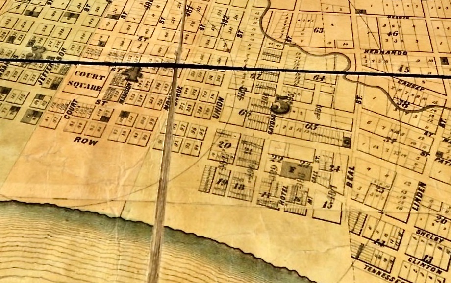
The original tract of land from the river to Trezevant St. (today’s East Parkway) and the legacy of John Rice figure prominently in the history of Union Avenue in that the name Rice appears along the future Union Ave in area maps prior to 1870 (above and below), when the city limits ended at today’s Manassas Street, and Union Street (as it was called) ended at today’s Marshall Ave (then part of Pigeon Roost Road).
As shown in the 1858 map below, Union St. (left arrow) begins at the river’s edge and today’s Wagner Place, travels east and ends at Pigeon Roost Road (today’s Marshall Ave). Rice Line Road (right arrow) begins at today’s Manassas St. and continues east into unincorporated Shelby County.

Overton Influence
It was John Overton who realized the possibilities of the Rice tract in 1794, and who hung on to his half through thick and thin. To Overton goes the credit for pushing the Memphis project at all times until his death in 1833, for planning the excellent lay-out of the town, and for supervising matters carefully during the early years.
Upon learning that a treaty was signed that would pay the Chickasaw Indians for the land on the bluff overlooking the Mississippi River, in October of 1818, John Overton wrote to General James Winchester to urge the general’s brother Marcus to get quick clearance, that speed is vital, that a town must be laid out “by this time 12 months” in order to beat “the owners of the property on the bluffs of the Mississippi above us.”
1819, January 7. The Chickasaw Treaty has been ratified and is now officially proclaimed in Washington. . . The new town at its founding thus had its proprietorship divided as follows: John Overton, a half; James Winchester and his brother’s heirs, three eighths; Andrew Jackson, an eighth.
It appears that plans for the new town were probably drawn up between about mid-November and this date (January 7). . . Overton and (James’ brother) Marcus Winchester did much of the work.
~Roper’s “The Founding of Memphis,” West Tennessee Historical Society papers
Laying out a town, from Smart City
On January 12, 1819, the three inveterate land speculators agreed to lay out a town site and hired surveyor William Lawrence to do it. His finished product was a rectangular town site containing 362 lots, laying parallel with the riverfront. None of the three developers planned to live in Memphis so Winchester’s son, Marcus, was sent to act as their sales agent.
The romanticized version goes like this: In 1819, Memphis was founded by Jackson, Overton, and Winchester, who, standing on the Fourth Chickasaw Bluff of the Mississippi River and looking at the untamed river and wilderness, foresaw a city of greatness. They named it Memphis after the legendary capital of Egypt located on another great river, the Nile.
The story is apocryphal. The three prominent Middle Tennesseeans never visited Memphis at the same time. Indeed, Jackson, if he visited at all (3), may have only visited the city briefly three years after its founding on his way to become governor of Florida. . .
~“Memphis 1.0: The City’s Historic Street Grid” by Tom Jones, from the Smart City Memphis blog, July 18, 2019
(3) Research indicates that Jackson set foot on the Chickasaw Bluffs just twice: in 1813 when his troops stopped overnight at Fort Pickering; and in 1821 briefly while campaigning for governor of Florida. (WTHS Papers) Though the three proprietors never convened in town together, it has been written that Jackson paid at least a visit to Paddy Meagher’s “Ordinary.”

Paddy Meagher’s “Ordinary” and Bell Tavern. Meagher’s Ordinary (a small tavern in his house) sat at 68 Overton, on the north side of the street between Chickasaw Street (today’s Front) and Main Street, from at least 1819. The Bell Tavern (pictured here) was built in 1826 on the east side of Chickasaw (Front) Street between Overton and Concord (today’s Shadyac Ave), and was taken down in 1905.
(postcard from historic-memphis.com)
McLemore: “The Fourth Founder”
There is some reason to say Memphis had four founders, although it is customary to say there were three. John Overton, Andrew Jackson and James Winchester shared in ownership of 5,000 acres, stretching from the river to where East Parkway was built many years later, and from Union to Vollintine. At the river end they laid off lots for sale in a town called Memphis. That was in 1819. What is often overlooked is that Jackson had only a one-eighth interstate’s in the venture. While the Chickasaw Nation still owned the land he sold his interest in three-eights of the ownership to the Winchester family.
While Memphis was still mostly hope, with few land sales and fewer settlers, Jackson checked out entirely by selling his remaining fragment of the proprietorship to John McLemore. That was in 1824. McLemore bought other land nearby. . . obtained three acres south of Union and west of Main. One of his major purchases was 208 acres of the highest park of the bluff, including remains of the long-abandoned Fort Pickering.”
~Paul Coppock’s Mid-South
Question: If the new town of Memphis was mapped out in January of 1819, why do we celebrate Memphis’ birthday in May?
Answer: Upon arrival in March and April of 1819, surveyors Marcus Winchester and James Blakemore and lead surveyor William Lawrence physically completed the surveying and staking out of the town in May, 1819, and May 22nd, when “the first lot, No. 53 on the southeast corner of Winchester and today’s Front Street, is conveyed to Benjamin Fooy.” ~Roper’s “The Founding of Memphis”, WTHS papers
This anthology series is brought to you in part with the help of our exclusive Preservation Sponsors at Renasant Bank.
A Surveyor Is Called In
William Lawrence was an “amiable young man” and “was recognized as a skillful surveyor and generally scientific type. Lawrence “acts as agent for the proprietorship of Overton and Jackson, and later for John C. McLemore, while Marcus Winchester “
March 20, 1819: “Marcus Winchester and William Lawrence arrive. . . According to Marcus’ reminiscences, steamboats were so scarce they didn’t see even one on the whole trip – a fact which didn’t prevent Overton from advertising ‘frequent’ steamboats.”
It is recalled that “the town of Memphis was laid off about the month of May, 1819.”
~Roper’s “The Founding of Memphis,” WTHS papers
Memphis’ Historic Street Grid Plan
“People congregate in cities to improve their prospects for social and economic interactions. . . A planner of a street layout, as a rule of thumb, should seek to maximize the market value of the private lots within the layout.” ~from “The Law and Economics of Street Layouts” by Robert C. Ellickson, 2012, lecture for the Alabama Law Review

By the criterion sited above, said Robert Ellickson in his 2012 lecture, “the street grid characteristic of the downtowns of most U.S. cities is largely successful. Although a grid layout has aesthetic shortcomings, it helps those who frequent a downtown to orient themselves and move about. A grid also is conducive to the creation of rectangular lots, which are ideal for siting structures and minimizing disputes between abutting landowners.”
In the late 18th Century, by virtue of the passage of the Land Ordinance of 1785 (a standardized system whereby settlers could purchase title to farmland in the undeveloped west), rectangular street grids were the popular norm when laying out city plans in developing U.S. cities. In cities like Baltimore, Philadelphia and Savanah, Georgia, the city grid system was already in place, and by the early 1800s emerging cities’ commissions and city planners were following suit.
Why rectangular grids? “A street layout of rectangular lots reduces the costs of land demarcations and land transactions,” said Mr. Ellickson in his 2012 lecture. “The tasks of a land surveyor are much simplified when the boundaries of a parcel are straight and meet at right angles.” In addition, he said, “One of the significant intangible merits of a grid design is its legibility. Because individuals can relatively easily map a grid in their heads, a rectangular layout helps enable them to know where they are and to imagine getting to where they want to go. Orienting a downtown street grid to true north-south, as in Chicago, further promotes circulation.”
The most famous grid plan, and according to many historians the most far-reaching and visionary, is New York’s Commissioners’ Plan of 1811, which laid out the classic and now ubiquitous Manhattan grid of uptown and crosstown streets.
Street plans map out and depict the locations of the rights-of-way that city governments or land owners eventually intend to open. In early 1800s Manhattan, when the New State Legislature appointed a commission to develop a plan, the areas north of today’s 14th Street were undeveloped. And in 1807, with the creation of the commission, local politicians and land owners sought for a plan that would provide for the orderly development and sale of the land.
In planning the new town of Memphis here upon the Fourth Chickasaw Bluff, John Overton, William Lawrence and Marcus Winchester no doubt took immediate cues from the street-grid precedents set in other cities.

The Plan of Memphis
The new town is one of the best-planned of its day. It is bounded on the east and north by the curving Bayou Gayoso, and on the west by the Wolf and Mississippi Rivers. To the south Union Avenue will be the limit for the survey, but it is worth noting that the southern boundary of Memphis was never officially fixed until 1832, at which time it was set only as far south as Jefferson Avenue. Even the 1826 act of incorporation did not name a south line.
Four major north-south streets are designed. From Jackson southward no buildings are to be allowed on the river side; all is to be a magnificent public promenade (4) called Mississippi Row, with no cuts in the bluff south of Market Street. Among the 362 lots four ample public squares are spaced carefully and optimistically, named by function: Auction, Exchange, Market, and Court.
~Roper’s “The Founding of Memphis,” WTHS papers
(4) Original Public Promenade
To their everlasting credit, the original Proprietors insisted that the town plan contain adequate public areas to help make it more livable. When Surveyor Lawrence drew his plans, he included one full city square and three half squares; he also set aside an area bordering the river as a public promenade. These lands were dedicated… for public usage.
The area designated for the Public Promenade bordered the Mississippi west of today’s Front Street, north of Union and south of Jackson. The Proprietors designated it as a place for walking and leisure. Over the years the question of the Proprietors’ intentions in setting aside the land was debated. One court in 1834 was of the opinion that the City had the right to use or dispose of the site as it so chose, and that this land should never be a deterrent to progress. Apparently this latter view prevailed.
~Cotton Row to Beale Street, John A. Sigafoos, 1979
“. . .Memphis was one of the best planned towns of its day. . . At the time, surveyor Lawrence wrote that only three non-native Americans lived at the site and there were no roads and only two ‘Indian trails’ leading to the bluffs. . . In other words, the street grid was a tremendous exercise in faith. . . What is striking is how this original grid has stood the test of time.” ~ from Tom Jones’ “Memphis 1.0: The City’s Historic Street Grid”
What’s in a avenue street name?
“The term ‘Union’ was in common use at the time,” said historian Wayne Dowdy of early nineteenth century city planning. “And I suspect it was in keeping with the overall patriotic theme they used for many of the first streets.”
The origins of the naming of Union Street in Memphis, Tenn., especially in relation to the naming conventions employed at the time, are not easily traceable. Here we finally locate some early sources and debunk a couple lasting myths about its naming.
Most names are chosen by real estate men when they subdivide. But changes are made when a community beyond the corporation line is annexed and it is found that some of the names are already used.
Through the official map and some ordinances Memphis has adopted the street names used in many other cities. There are, of course, streets named for the states, for other cities, for famous universities and schools, for colors, for fruit trees, nut trees and shade trees (like Poplar), for flowers and even for the birds and the bees, such as Sparrow Hop and Bee Bee.
~”History In Memphis Street Names,” by Paul R. Coppock for the West Tennessee Historical Society papers

Above: In the original Plan of Memphis, all streets were called just that, streets. And as noted earlier, the streets Auction, Exchange, Market, and Court were named by function. North of Poplar Avenue streets were named after the first three founders Winchester, Jackson and Overton. South of Poplar, the streets Washington, Adams, Jefferson, Monroe and Madison were named for the first five U.S. Presidents. In the original plan, today’s Front Street was named Mississippi Row, which overlooked the expansive (planned) Public Promenade that stretched from Union to Jackson (north of Jackson, Mississippi Row becomes Chickasaw Street; south of Union, it was Shelby Street). The main north-south commercial thoroughfare was appropriately called Main, and thereafter eastward streets were numbered, starting with Second.
Street names honored former U.S. Presidents and the three proprietors. There were also streets named to coincide with the four public squares, and some were given standard names such as Main Street, Second Street and Third Street. Shortly after the birth of Memphis, Union became the political boundary between the city and the rival village of South Memphis. ~Sigafoos’ Cotton Row to Beale Street
Union Myth. Two myths about the naming of Union have continued to perpetuate over the years: that one it so named for a union with South Memphis; two that it has something to do with the Civil War.
Union Avenue, from Johnson & Russell‘s Memphis: An Architectural Guide

In 1849, Memphis and South Memphis agreed to merge under the name of Memphis, and the south city limit was moved from Union to Calhoun Street (today’s G.E. Patterson). There is a story that the name of Union Avenue resulted from the fact that it was the border between these two towns. It was the border, but it is also called “Union” on the 1827 map of the city, at a time when there was not yet a South Memphis.
~Johnson & Russell’s Memphis: An Architectural Guide
Myth, from Jimmy Ogle, as told to the Memphis Flyer’s John Branston in 2013
Downtown Myth #6 – Union Avenue gets its name from the Civil War: This is an Ogle favorite. “The name had nothing to do with the Civil War Union occupation nor the merger with South Memphis in 1850,” he said. Our city’s original street names, including Union, are on the original survey and map of 1819 — more than 40 years before the onset of the Civil War.


Finally, how then was Union so named? A 1963 feature about the widening and beautification of Union Avenue East (as it was referred to in that era), published by The Commercial Appeal in August of that year, attributes the naming to Andrew Jackson:
Historians credit the naming of the street to Gen. Andrew Jackson, one of the founders of Memphis in 1819; he said, “Our Federal Union; It must and shall be preserved.” The street was named for the union of the states.
~The Commercial Appeal, August 21, 1963
This naming association would seem logical enough, and the most definitive evidence we’ve seen so far of the origins of the Union name; however, we recall that our research has shown that Jackson had only passing involvement with the founding of Memphis, and no involvement at all in the actual planning. Therefore, the editors of this anthology remain not entirely convinced that this reference proves beyond a shadow of a doubt the roots of the naming of Union Avenue. The myths live on, for now. (updated Jan. 18, 2021)
A City Charter, At Last
Dividing the bluff into lots, the proprietors (Jackson, Overton, Winchester) hoped to increase the area’s population through land sales, a stable government and expanded trade. This put them in direct conflict with many of the original settlers, or squatters, who did not own titles to their land and were fearful of being displaced by newer, wealthier arrivals. . .
Recognizing the discontent brewing among some of the squatters, and wishing to appease them, the proprietors offered many of them titles to their land. This did not satisfy the most strident member of the anti-proprietors faction, Isaac Rawlings. . . Sharing his neighbors’ view that high taxes would be an inevitable result of incorporation, Rawlings organized a public meeting to debate the incorporation charter. . . (explaining that) “its support would be a severe hardship on several of the poor people living in the outskirts of the proposed town.” The argument convinced the proprietor faction to contract the town’s limits and exclude the poorest section of the bluff. ~Excerpts from A Brief History of Memphis, by G. Wayne Dowdy
In 1826, after several attempts and despite much opposition, Judge Overton finally succeeded in having a charter issued to Memphis by the State Legislature. On April 26, 1827, the election of the first Board of Alderman was held and promptly the first mayor (Marcus Winchester) and city officials were elected by the board.
This is the second installment of StoryBoard’s “Union Avenue Anthology.” If you missed the introduction, you can read it here: “Whatever Happened to Union Avenue?” (the series’ bibliography and resources can be found there as well)
This anthology series is brought to you in part with the help of our exclusive Preservation Sponsors at Renasant Bank.
You must be logged in to post a comment.